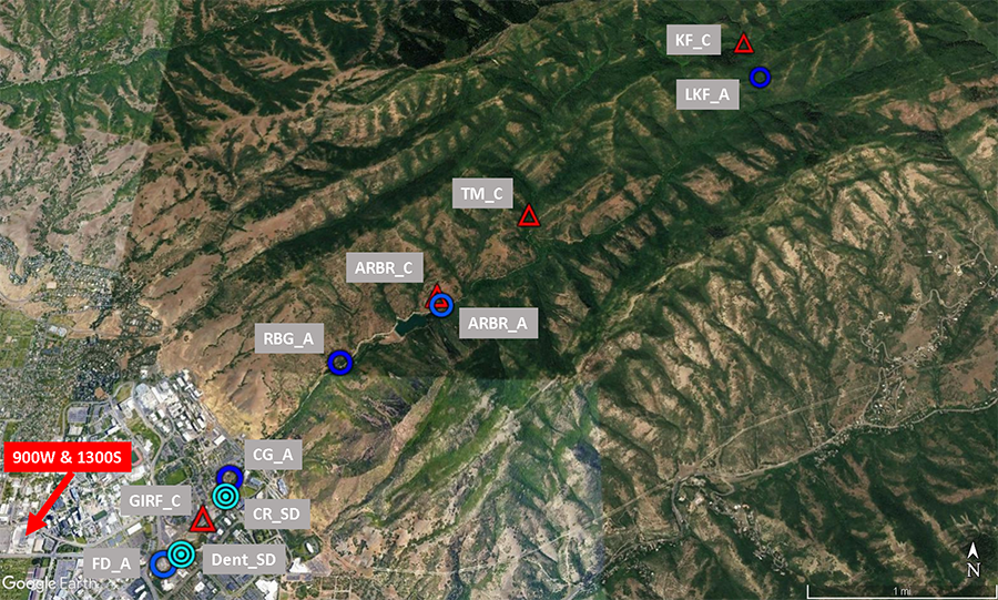
Red Butte Creek originates in the mountains of northeastern Salt Lake County. After exiting the canyon, the creek makes a rapid transition to built-out, urbanized land use through the University of Utah campus and into Salt Lake City before discharging into the Jordan River. The creek’s ecosystems and proximity to campus make it an outstanding resource for scientific and educational research.
- For access to the Red Butte Canyon research natural area, the U of U Red Butte Creek Vision, and related research projects, go to redbuttecreek.utah.edu.
- As part of our Stormwater Management Plan, the University of Utah strives to prevent pollution from entering Red Butte Creek as well as the local storm drain system. The U prohibits the commencement, conduct or continuance of any illegal, or non-storm water discharge on campus. For more information please visit: https://oehs.utah.edu/topics/stormwater-management-program.
In 2013, The Wasatch Environmental Observatory (WEO) Red Butte Creek Network was constructed with support from the NSF funded iUTAH project (iutahepscor.org). The network consists of 4 Climate Stations, 7 Aquatic Stations, and 2 Storm Drain monitoring stations located from the headwaters of Red Butte Canyon to the confluence of Red Butte Creek and the Jordan River. Sensors at each station measure a range of standard metrological and hydrologic variables at a fifteen minute time resolution. Raw data with complete metadata is uploaded daily to the open access hydrologic data repository, hydroshare.org (links below). Contact Dr. Paul Brooks (paul.brooks@utah.edu) at the University of Utah with questions about the network.

| Station | Code | RAW Data | Quality Controlled Data | Rating Curves |
|---|---|---|---|---|
| Climate Stations: | ||||
| GIRF Climate | GIRF_C | GIRF_C RAW Data | GIRF_C QC Data | n/a |
| Above Red Butte Reservoir Climate | ARBR_C | ARBR_C RAW Data | ARBR_C QC Data | n/a |
| Todds Meadow Climate | TM_C | TM_C RAW Data | TM_C QC Data | n/a |
| Knowlton Fork Climate | KF_C | KF_C RAW Data | KF_C QC Data | n/a |
| Aquatic Stations: | ||||
| Lower Knowlton Fork Aquatic | LKF_A | LKF_A RAW Data | LKF_A QC Data | Discharge calculated using flume. No published rating curve |
| Above Red Butte Reservoir Aquatic | ARBR_A | ARBR_A RAW Data | ARBR_A QC Data | USGS Station at this site -- no rating curve |
| Red Butte Gate Aquatic | RBG_A | RBG_A RAW Data | RBG_A QC Data | RBG_A rating curves |
| Cottam's Grove Aquatic | CG_A | CG_A RAW Data | CG_A QC Data | CG_A rating curves |
| Foothill Drive Aquatic: | FD_A | FD_A RAW Data | FD_A QC Data | FD_A rating curves |
| 1300 E Aquatic: | 1300E_A | 1300E_A RAW Data | 1300E_A QC Data | Rating curve not yet published. |
| 900 W Aquatic: | 900W_A | 900W_A RAW Data | 900W_A QC Data | Discharge calculated with insitu velocity sensor. No rating curve |
| Storm Drain Stations: | ||||
| Dentistry Storm Drain | Dent_SD | Dent_SD RAW Data | Dent_SD QC Data | n/a |
| Connor Road Storm Drain | CR_SD | CR_SD RAW Data | CR_SD QC Data | n/a |
